Estimating latitude with a simple gnomon is a classic method that dates back to ancient astronomers and even Viking navigators. By measuring the Sun’s elevation at local noon, you can calculate the angle between the Sun and the horizon, and from that infer your position north or south of the equator. This experiment guides you through building a sturdy cardboard gnomon, recording shadow lengths, and performing the trigonometric calculation.
Before You Begin
- Choose a clear day with at least two hours of uninterrupted sunlight around solar noon (approximately 11 am–1 pm local time). Cloud cover will affect shadow clarity.
- Identify a flat, level surface such as a concrete patio, a large table, or a packed lawn. The surface must stay level for the entire observation period.
- Determine the approximate time of local solar noon for your location. You can use online calculators or the equation: solar noon ≈ 12:00 pm – (4 min × longitude ÷ 15°) + time‑zone correction ± equation‑of‑time. A rough estimate within ±5 minutes is sufficient.
- Adult supervision is required for handling a sharp knife, measuring tools, and for ensuring safety when working outdoors.
Materials
- Sturdy cardboard (minimum 2 mm thickness), about 30 cm × 30 cm.
- Thin but rigid paper or cardstock for the gnomon (≈ 0.5 mm thick).
- Ruler or measuring tape (metric preferred).
- Protractor (0°–180°).
- Sharp craft knife or scissors.
- Masking tape or glue.
- Compass (magnetic) to find true north (or a smartphone compass app).
- Digital camera or smartphone for photographing shadow positions (optional).
- Notebook or worksheet for recording data.
- Calculator (or spreadsheet) for trigonometric functions.
Testable Question
How accurately can a cardboard gnomon determine the observer’s latitude when the Sun’s noon altitude is measured on a clear day?
Hypothesis
If the gnomon is perfectly vertical and the shadow length is measured at true solar noon, then the calculated latitude will be within ±1° of the known latitude obtained from a GPS or map.
Variables and Controls
- Independent variable: The measured shadow length at solar noon.
- Dependent variable: The calculated latitude.
- Controlled variables: Gnomon height, vertical alignment, level of the base, date of observation, and measurement units. The experiment is performed on the same day for all trials to keep the Sun’s declination constant.
Procedure (Steps)
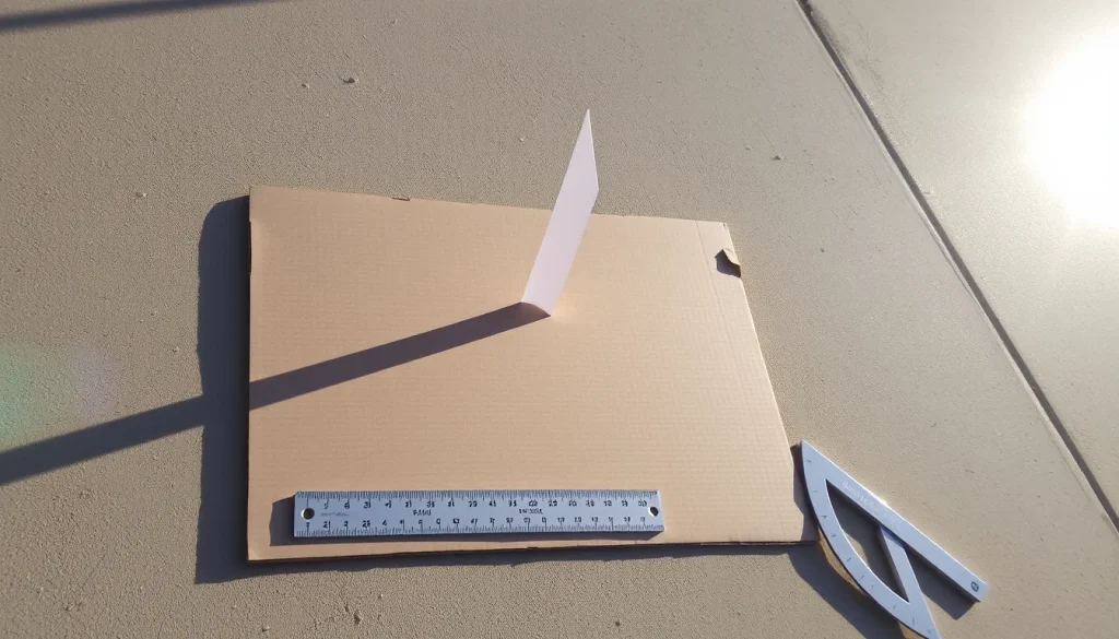
- Construct the gnomon. Cut a rectangular piece of cardboard (≈ 30 cm × 30 cm) for the base. Cut a thin strip of paper 20 cm long and 1 cm wide. Attach the strip at the center of the base so that it stands upright and exactly vertical. Use a level (or a plumb line) to verify verticality. Secure with tape.
- Mark the base. Draw a thin cross‑hair at the point where the gnomon meets the base; this is the shadow origin.
- Determine true north. Use a compass, correcting for magnetic declination, or align the base so that the shortest shadow at solar noon points toward true north.
- Measure the gnomon height. Use a ruler to record the vertical height (h) from the base to the top of the strip in millimeters. Note this value; it will be used in the trigonometric calculation.
- Observe solar noon. As the estimated solar noon approaches, watch the shadow length decreasing. At the moment the shadow is shortest (or within ±30 seconds of the calculated solar noon), record the shadow length (s) from the cross‑hair to the tip of the shadow. Use a ruler placed on the base for accuracy.
- Record environmental data. Note the date, local time (to the nearest minute), temperature, and cloud conditions.
- Repeat the measurement. Perform at least three independent shadow‑length measurements on the same day, removing and repositioning the gnomon each time to assess repeatability.
- Calculate solar altitude. Use the right‑triangle relation: tan α = h / s, where α is the Sun’s altitude angle above the horizon. Compute α = arctan(h / s).
- Find latitude. On the date of observation, look up the Sun’s declination (δ) from an almanac or online solar calculator. Then latitude (φ) is given by φ = 90° – α + δ (for the Northern Hemisphere) or φ = 90° – α – δ (for the Southern Hemisphere). Adjust sign according to your hemisphere.
- Compare. Compare the calculated latitude with the known latitude (e.g., from a GPS phone app). Compute the error.
What to Observe and Record
- Gnomon height (mm).
- Shadow length (mm) for each trial.
- Time of measurement (local solar time).
- Sun’s declination for the date (degrees).
- Calculated altitude angle (α) and latitude (φ).
- Observed error compared to known latitude.
Data Table
| Trial | Shadow length s (mm) | Altitude α (°) | Latitude φ (°) | Error vs. known (°) |
|---|---|---|---|---|
| 1 | ||||
| 2 | ||||
| 3 |
Calculations
Example (illustrative only):

- Gnomon height h = 200 mm.
- Measured shadow s = 150 mm.
- α = arctan(200 / 150) ≈ 53.1°.
- For June 21 (approx. declination δ = +23.44°), latitude φ = 90° – 53.1° + 23.44° ≈ 60.3° N.
- If the known latitude is 61.0° N, the error is 0.7°.
Repeat for each trial and compute the average error.
The Science Explained
A gnomon casts a shadow whose length depends on the Sun’s elevation angle above the horizon. At local solar noon the Sun reaches its highest point for the day, so the shadow is at its shortest. The geometry forms a right triangle with the gnomon as the opposite side (height) and the shadow as the adjacent side. The tangent of the solar altitude (α) equals the ratio of height to shadow length (tan α = h / s). Knowing α and the Sun’s declination (δ) for that date, the observer’s latitude (φ) follows from the spherical‑trigonometry relation φ = 90° – α ± δ, where the sign depends on the hemisphere. This method is described in classic gnomon tutorials and Viking navigation studies【1†https://people.tamu.edu/~kevinkrisciunas/gnomon.pdf】【4†https://eaae-astronomy.org/images/workshops/latitude-gnomon-and-quadrant-for-the-whole-year/latitude-gnomon-and-quadrant-for-the-whole-year.pdf】.
Repeated Trials and Accuracy
Performing three or more trials helps identify random errors such as slight tilt of the gnomon, uneven ground, or timing inaccuracies. Calculate the mean latitude and its standard deviation to express confidence. If the standard deviation exceeds 0.5°, revisit the setup: ensure the base is truly level, re‑check verticality, and improve timing precision (use a stopwatch synchronized with a solar‑noon calculator).
Troubleshooting
- Shadow not sharp: Use a narrow, pointed gnomon (paper strip) and a smooth, light‑colored base to increase contrast.
- Gnomon tilts: Verify verticality with a plumb line before each trial.
- Incorrect solar noon: Use an online solar‑noon calculator for your exact longitude and date; a 5‑minute error translates to a noticeable change in shadow length.
- Clouds or haze: Reschedule the experiment; diffuse light makes the shadow edge ambiguous.
Cleanup and Storage
Collect the cardboard pieces, store the gnomon in a dry place, and discard any torn paper scraps. The ruler, protractor, and compass can be returned to the household toolbox.
Next Steps
Extend the investigation by repeating the experiment on the equinoxes, when the Sun’s declination is 0°, simplifying the latitude formula to φ = 90° – α. You can also compare results from different dates to see how the Sun’s declination changes the shadow length, reinforcing the seasonal cycle concept.
Related terms
- Gnomon
- A vertical stick or object that casts a shadow, used to measure the Sun’s altitude.
- Latitude
- The angular distance north or south of the Earth’s equator, expressed in degrees.
- Solar declination
- The angle between the Sun’s rays and the Earth’s equatorial plane, changing throughout the year.
Sources & references
- Determining Your Latitude with a Gnomon – Texas A&M University, https://people.tamu.edu/~kevinkrisciunas/gnomon.pdf
- LATITUDE GNOMON AND QUADRANT FOR THE WHOLE YEAR – EAAE Summer School, https://eaae-astronomy.org/images/workshops/latitude-gnomon-and-quadrant-for-the-whole-year/latitude-gnomon-and-quadrant-for-the-whole-year.pdf